Creekside Meadows: 23833 Clear Creek Road, Rockbridge, OH 43149
Hours: Year-round, 6:30 AM – dark
Phone: 740-969-8210
Park Map
Tap to view full size. Download map
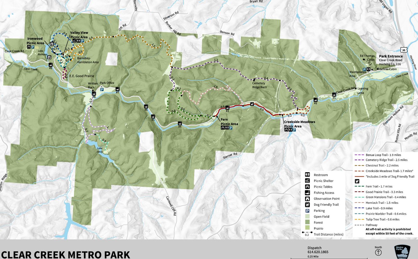
Source: Columbus and Franklin County Metro Parks
Overview
Clear Creek Metro Park spans Hocking and Fairfield Counties and contains the 4,729-acre Allen F. Beck State Nature Preserve — Ohio's largest state nature preserve. The park features Black Hand sandstone cliffs, ravines, and creeks running through forests that range from Canadian hemlocks and ferns to oak-hickory uplands to Ohio's last remaining colonies of wild rhododendron.
Managed by Columbus and Franklin County Metro Parks, Clear Creek is free to visit and offers 10 hiking trails ranging from the easy 0.3-mile Good Prairie loop to the difficult 2.5-mile Cemetery Ridge traverse.
All 10 Trails
Benua Trail
Moderate–Difficult · 1.9 miles · Dirt & gravel
Loop trail through woods and fields leading to Lake Emily. Opened in 2021, providing access to the historic Benua property.
Cemetery Ridge Trail
Moderate–Difficult · 2.5 miles · Dirt & gravel
Begins with a steep zigzag ascent through the woods, peaking at about 700 feet. At the top of the ridge, the trail alternates between forest and meadows with rewarding views.
Chestnut Trail
Difficult · 2.2 miles · Dirt & gravel
Passes through valleys with sandstone formations and crosses forested ridges. This trail goes through terrain reminiscent of the main Hocking Hills park — sandstone outcroppings and deep-cut ravines.
Creekside Meadows Trail
Easy · 1.7 miles · Grass · Pets OK (1-mi section)
Follows the banks of Clear Creek through open fields. The 1-mile section west of Starner Road is the only pet-friendly trail in the entire park. Great for families and casual walkers.
Fern Trail
Moderate–Difficult · 1.7 miles · Dirt
Traverses a steep ridge through a forest of pines and hemlocks. The fern-covered hillsides give this trail its name and its atmosphere.
Good Prairie Trail
Easy · 0.3 miles · Dirt & gravel
Short loop around a prairie restoration. A quick leg-stretcher that pairs well with longer trails in the park.
Hemlock Trail
Difficult · 1.5 miles · Dirt & gravel
Descends and ascends a steep ravine through shady hemlock groves, past sandstone outcroppings, across carpets of ferns, and over ridges topped with hardwood trees. One of the most scenic trails in the park.
Lake Trail
Moderate–Difficult · 0.9 miles · Dirt
Winds through the woods to an observation deck overlooking Lake Ramona. The deck provides a quiet spot for birdwatching.
Prairie Warbler Trail
Easy–Moderate · 0.6 miles · Dirt
Crosses a rolling hilltop, loops around a meadow, and passes through the woods. Named for the prairie warblers that nest in the meadow habitat.
Tulip Tree Trail
Moderate–Difficult · 0.6 miles · Dirt
Loops through the woods along a rolling hillside among towering tulip poplars.
Facilities
Two picnic areas (Fern and Creekside Meadows) with tables, grills, and vault restrooms. The Barnebey-Hambleton Day Use Area offers an additional shelter. Non-reservable shelters are first-come, first-served. Fishing access is available along Clear Creek Road, at the 5-acre Lake Ramona, and from the dam at Lake Emily.
Getting There
Clear Creek is located about 30 miles northwest of Old Man's Cave. From Hocking Hills, take SR-664 north to US-33 west toward Lancaster, then head south on Clear Creek Road. From Columbus, it's approximately 45 minutes southeast via US-33 East through Lancaster.